Geography — Suggested Paper 5
105 minutes70 marks Questions from 2016–2026
A suggested paper: every question is a real ICSE board question, chosen from different years and arranged in the current pattern. Start the timed test to have your written answers marked. Question 1 is set on a Survey of India toposheet that cannot be reproduced here.
Part I (30 marks)
Attempt all questions from this Part.
2. On the outline map of India provided:
2(i). Mark and label the Eastern Ghats.
[1 mark]2(vi). Shade and label the Thar Desert.
[1 mark]2(ii). Mark and name Nilgiris.
[1 mark]2(iv). Mark using arrows, the direction of the South West Monsoon wind during summer over the Arabian Sea and label it.
[1 mark]2(ix). Shade and name the Coromandel Coastal Plain.
[1 mark]2(iii). Shade and label Kanara coast.
[1 mark]2(vii). Shade and label a densely-populated region in India.
[1 mark]2(v). Shade and name the Gulf of Mannar.
[1 mark]2(x). Shade a region with alluvial soil in South India.
[1 mark]2(viii). Mark and label the Nathu-La pass.
[1 mark]3. Choose the correct answers to the questions from the given options. (Do not copy the questions, write the correct answers only.)
3(i). Which of the following helps in soil conservation?
[1 mark]- (a)Afforestation
- (b)Overgrazing
- (c)Mining
- (d)Shifting agriculture
3(ii). Which of the following is NOT a characteristic of desert vegetation?
[1 mark]- (a)Short, stunted growth of vegetation
- (b)Thick fleshy stems
- (c)Broad leaves
- (d)Long and deep roots
3(iii). Which of the following is a ground water source?
[1 mark]- (a)Pond
- (b)Lake
- (c)Spring
- (d)River
3(iv). Which scale out of the following, that is printed on the topographical map, is considered a special scale?
[1 mark]- (a)Statement Scale.
- (b)Representative fraction.
- (c)Linear Scale.
- (d)Graphical Scale.
3(v). Why is the central part of Deccan plateau a dry area?
[1 mark]- (a)It is away from the sea
- (b)There is no barrier in the part of rain bearing wind
- (c)It is due to jet Streams
- (d)It is a rain shadow area of Western Ghats
3(vi). Balaghat: Manganese:: Mumbai High: ____________________
[1 mark]- (a)Copper
- (b)Coal
- (c)Iron Ore
- (d)Petroleum
3(vii). Which industry is ideally located close to the raw material producing area?
[1 mark]- (a)Silk industry
- (b)Jute industry
- (c)Cotton textile industry
- (d)Sugar industry
3(viii). The picture given below depicts the use of waterway as a means of transport. Identify the pair of cities which are most likely to be the terminal cities for the waterway shown in the above picture:
[1 mark]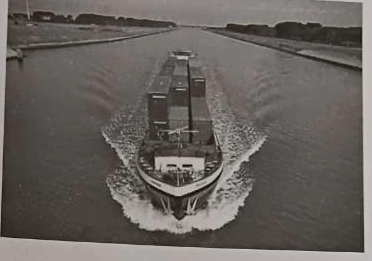
- (a)Prayagraj and Haldia
- (b)Mumbai and Goa
- (c)Chennai and Vishakhapatnam
- (d)Kochi and Mangaluru
3(ix). Name the method used to prevent soil erosion by running water
[1 mark]- (a)Terrace farming
- (b)Strip cropping
- (c)Shelter belts
- (d)Leaving the land fallow
3(x). The type of natural vegetation shown in the picture given below is found in:
[1 mark]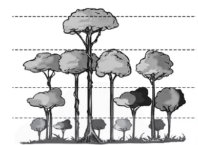
- (a)Tropical desert
- (b)Tropical deciduous
- (c)Tropical evergreen
- (d)Littoral forest
Part II (50 marks)
Attempt any five questions from this Part.
4(i). Differentiate between Intensive farming and Extensive farming.
[2 marks]4(ii). Mention two problems faced by the Indian farmers.
[2 marks]4(iii)(a). Give one advantage of transplantation method of sowing rice.
[1 mark]4(iii)(b). What is 'Ginning'?
[1 mark]4(iii)(c). Name any two pulses grown in India.
[1 mark]4(iv)(a). What is meant by 'Retting'?
[1 mark]4(iv)(b). What kind of soil is required for the cultivation of tea?
[1 mark]4(iv)(c). Why is pruning necessary for tea plant?
[1 mark]5(a)(i). Why is iron ore called the back bone of our modern industry?
[1 mark]5(a)(ii). Mention two uses of iron ore.
[1 mark]5(b). Mention one agricultural and one industrial problem solved by the Bhakra Nangal Dam.
[2 marks]5(c)(i). Name the state that is the leading producer of Manganese.
[1 mark]5(c)(ii). Name the mineral oil field of India which is the largest producer of Petroleum.
[1 mark]5(c)(iii). Mention two advantages of using Geothermal energy over coal.
[1 mark]5(d)(i). Mention one disadvantage of using natural gas as a source of power.
[1 mark]5(d)(ii). How is the residue from a Bio-gas plant put to use?
[1 mark]5(d)(iii). Why is the use of alternative sources of energy becoming essential in modern time?
[1 mark]6(a). How do trees in the Tropical desert forests adapt themselves to the dry climate?
[2 marks]6(b). Name the tree as per its characteristics given below: 1. The wood is hard and suitable for ship building. 2. The stilt roots are underwater during high tide.
[2 marks]6(c). Explain why the forest cover in India is shrinking.
[3 marks]6(d). Name the natural vegetation found in the following regions:
6(d)(i). The western slopes of the Western Ghats.
[1 mark]6(d)(ii). The Nilgiris.
[1 mark]6(d)(iii). Western Rajasthan.
[1 mark]7(a). What is soil erosion? Mention two steps that could be taken to prevent soil erosion.
[2 marks]7(b). Mention two similarities between red soil and laterite soil.
[2 marks]7(c). Give a geographical reason for each of the following:
7(c)(i). Alluvial soil differs in texture.
[1 mark]7(c)(ii). Black soil does not get leached.
[1 mark]7(c)(iii). Khadar is more fertile than bhangar.
[1 mark]7(d). Define the following:
7(d)(i). Sheet erosion
[1 mark]7(d)(ii). Soil conservation
[1 mark]7(d)(iii). In situ soil
[1 mark]8(a). "Without irrigation, development of agriculture is difficult in India." Clarify the statement by giving two reasons.
[2 marks]8(b). Mention two factors which are essential for the development of tube well irrigation.
[2 marks]8(c). Give one reason for each of the following:
8(c)(i). The Northern Plain of India is found suitable for canal irrigation.
[1 mark]8(c)(ii). Tank irrigation is an important method of irrigation in Karnataka.
[1 mark]8(c)(iii). Although expensive, yet, sprinkler irrigation is gaining popularity in recent times.
[1 mark]8(d)(i). What is rain water harvesting?
[1 mark]8(d)(ii). Mention two objectives of rain water harvesting.
[2 marks]9(i). Why is it important to have a well developed means of transport in India?
[2 marks]9(ii). "Though an expensive mode of transport, Airways is gaining popularity in India." Explain giving two reasons.
[2 marks]9(iii)(a). Why are South Indian rivers not ideal for inland water transport?
[1 mark]9(iii)(b). Mention two advantages of waterways.
[2 marks]9(iv)(a). Why are roadways considered more important than any other means of transport?
[1 mark]9(iv)(b). Mention two advantages of using railways as means of transport.
[2 marks]10(a). Give two reasons as to why there is a need for safe waste disposal.
[2 marks]10(b). How can waste be reused? Explain with the help of an example.
[2 marks]10(c). Mention one way in which waste accumulation has an effect on the following:
10(c)(i). aquatic life
[1 mark]10(c)(ii). terrestrial life
[1 mark]10(c)(iii). landscape
[1 mark]10(d). What do you mean by the following terms?
10(d)(i). Segregation.
[1 mark]10(d)(ii). Composting.
[1 mark]10(d)(iii). Dumping.
[1 mark]11(i). 'Severe cyclonic storms are often formed over the Bay of Bengal during the retreating monsoon season'.
11(i)(a). Name two states that are affected by tropical cyclones on the eastern coast of India.
[1 mark]11(i)(b). The temperate cyclones cause less damage than the tropical cyclones. Give any two points to support this statement.
[1 mark]11(ii)(a). Name the local wind that causes rainfall in the states of Assam and West Bengal in the month of April.
[1 mark]11(ii)(b). How is this rainfall beneficial for the states mentioned above?
[1 mark]11(iii). With reference to Figure A and Figure B given below, answer the questions that follow:
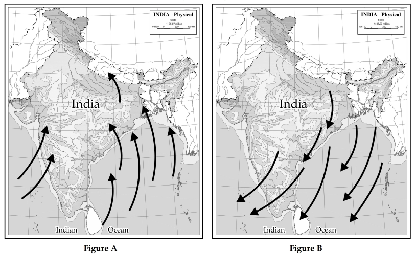
11(iii)(a). Name the winds shown by arrows in Figure A and Figure B.
[1 mark]11(iii)(b). How is the wind shown in Figure A different from the one shown in Figure B?
[2 marks]11(iv). Study the climate data of station X and answer the following questions:

11(iv). Month: Jan Feb Mar Apr May Jun Jul Aug Sep Oct Nov Dec | Temp °C: 24.0, 25.4, 26.7, 28.3, 30.0, 28.9, 27.6, 27.4, 27.3, 27.1, 27.0, 25.0 | Rainfall cm: 0.25, 0.25, –, –, 1.75, 50.2, 61.0, 37.0, 27.0, 4.75, 1.50, –
11(iv)(a). What is the annual range of temperature for station X?
[1 mark]11(iv)(b). Which is the wettest month?
[1 mark]11(iv)(c). Name the wind which brings rainfall for station X during the rainy season.
[1 mark]12(a). 'The Iron and Steel industry constitutes the backbone of modern industrial economy.' Give two reasons to justify the statement.
[2 marks]12(b). 1. Name an Iron and Steel Industry set up in Orissa with the help of a famous German firm. 2. From where does the industry named in b(i) get its iron ore and manganese?
[2 marks]12(c). Name a manufacturing centre for each of the following industries:
12(c)(i). Aircraft
[1 mark]12(c)(ii). HMT
[1 mark]12(c)(iii). Railway coaches
[1 mark]12(d). Name two products each of the following industries:
12(d)(i). petrochemical industry
[1 mark]12(d)(ii). heavy engineering industry.
[1 mark]12(d)(iii). electronic industry.
[1 mark]