Geography — Suggested Paper 1
105 minutes70 marks Questions from 2016–2026
A suggested paper: every question is a real ICSE board question, chosen from different years and arranged in the current pattern. Start the timed test to have your written answers marked. Question 1 is set on a Survey of India toposheet that cannot be reproduced here.
Part I (30 marks)
Attempt all questions from this Part.
2. On the outline map of India provided:
2(i). Mark and name the Karakoram Pass.
[1 mark]2(ii). Mark and name the Gulf of Kutch.
[1 mark]2(iii). Mark and name the River Brahmaputra.
[1 mark]2(ix). Mark and name the Satpura.
[1 mark]2(iv). Mark with a dot and name Chennai.
[1 mark]2(v). Mark and name Kolkata.
[1 mark]2(vi). Mark C on the coal fields in Jharia.
[1 mark]2(vii). Shade and label the Konkan coastal plain.
[1 mark]2(viii). Mark with an arrow and label the direction of Western disturbance.
[1 mark]2(x). Shade and label the Gangetic Plain.
[1 mark]3. Choose the correct answers to the questions from the given options. (Do not copy the questions, write the correct answers only.)
3(i). Name the soil that is found in central Deccan plateau?
[1 mark]- (a)Black soil
- (b)Alluvial soil
- (c)Red soil
- (d)Laterite soil
3(ii). Identify the option which is most similar to: Tropical Evergreen vegetation : Tall trees and hardwood
[1 mark]- (a)Tropical Deciduous vegetation : Pure stands
- (b)Tropical Desert vegetation : Small leaves and spines
- (c)Coniferous forests : Mountain
- (d)Littoral vegetation : Boat making
3(iii). What is the importance of "DRIP IRRIGATION"?
[1 mark]- (a)It is an ultra-modern system of irrigation.
- (b)It is cheaper than other sources.
- (c)It can irrigate more area with less usage of water.
- (d)It is used by almost all farmers in India.
3(iv). What does nearness of contour lines indicate?
[1 mark]- (a)It indicates steep slope.
- (b)It indicates gentle slope.
- (c)It indicates desert area.
- (d)It indicates irregular area.
3(v). Mawsynram, the rainiest place in the world, gets the rain from:
[1 mark]- (a)South-west monsoon wind - Arabian Sea branch
- (b)South-west monsoon wind - Bay of Bengal branch
- (c)Western Disturbance
- (d)North-east monsoon wind
3(vi). Hirakud dam is based on which of the following rivers?
[1 mark]- (a)River Godavari
- (b)River Mahanadi
- (c)River Krishna
- (d)River Narmada
3(vii). Which industry amongst the following has revolutionised the lifestyle of the Indian masses in recent years?
[1 mark]- (a)Cotton Textile
- (b)Electronic
- (c)Iron and Steel
- (d)Sugar
3(viii). Which of the following is NOT a problem of Indian agriculture?
[1 mark]- (a)Dependence on monsoon
- (b)Small land holdings
- (c)Two main cropping seasons
- (d)Use of traditional methods of farming
3(ix). Which of the following is a staple food grain of Indians?
[1 mark]- (a)Wheat
- (b)Rice
- (c)Gram
- (d)Arhar
3(x). The collection of discarded materials and converting them into useful products is:
[1 mark]- (a)Recycling
- (b)Processing
- (c)Reducing
- (d)Composting
Part II (50 marks)
Attempt any five questions from this Part.
4(a). Give a reason for the significance of irrigation in: 1. Punjab. 2. Rajasthan.
[2 marks]4(b). Name a state where: 1. Tube wells are common. 2. Tank irrigation is popular.
[2 marks]4(c). Give one geographical reason for each of the following:
4(c)(i). Sprinkler irrigation is practiced in arid and semi-arid regions.
[1 mark]4(c)(ii). A tube well should be installed in a fertile and productive region.
[1 mark]4(c)(iii). Canal irrigation is more suitable in the Northern Plains.
[1 mark]4. Study the diagram below and answer the questions that follow:
4(d). 1. Name the activity shown in the diagram. 2. Give two objectives of the activity named in (d)(i).
[3 marks]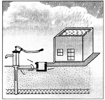
5(a). Give two reasons to explain as to why we need to conserve our forest resource.
[2 marks]5(b)(i). Mention two conditions required for the growth of Littoral Forest.
[1 mark]5(b)(ii). State one characteristic feature of the forest found in the Nilgiri Hills.
[1 mark]5(c)(i). Give two reasons to explain as to why the Tropical Evergreen Forests are difficult to exploit for commercial purpose.
[2 marks]5(c)(ii). Name any two trees found in Tropical Evergreen forests.
[1 mark]5(d). Briefly explain each of the following:
5(d)(i). The trees in the Tropical Desert Forest have stunted growth.
[1 mark]5(d)(ii). There is a gradual increase in the forest cover in India in recent times.
[1 mark]5(d)(iii). The trees in Monsoon Deciduous Forests, shed their leaves for about 6-8 weeks during March and April.
[1 mark]6(a). With reference to the cultivation of tea answer the following:
6(a)(i). Why is tea grown on hill slopes?
[1 mark]6(a)(ii). Why tea bushes have to be pruned at regular intervals?
[1 mark]6(b). With reference to rice cultivation answer the following:
6(b)(i). Why does the cultivation of rice require a lot of manual labour?
[1 mark]6(b)(ii). Mention two geographical conditions which suit the cultivation of rice.
[1 mark]6(c). Give a geographical reason for each of the following:
6(c)(i). Cotton is a labour intensive crop.
[1 mark]6(c)(ii). Jute is retted after it has been harvested.
[1 mark]6(c)(iii). The growing of pulses is important in India.
[1 mark]6(d)(i). Why is agriculture important in India?
[1 mark]6(d)(ii). Name the two main agricultural seasons of India.
[1 mark]6(d)(iii). What is mixed farming?
[1 mark]7(i)(a). Based on the ownership, what type of industry is Visakhapatnam Steel Plant?
[1 mark]7(i)(b). What is meant by cooperative sector industry?
[1 mark]7(ii). Explain the following terms:
7(ii)(a). Sericulture
[1 mark]7(ii)(b). Integrated steel plant
[1 mark]7(iii). Give one reason to explain each of the following:
7(iii)(a). Mini-steel plants help in conservation of coal.
[1 mark]7(iii)(b). Location of sugar industry is shifting to the Southern part of India.
[1 mark]7(iii)(c). The electronic industry is growing at a fast rate.
[1 mark]7(iv)(a). State two conditions that favour the location of cotton textile industry in Ahmedabad.
[2 marks]7(iv)(b). State any one advantage of locating Iron and Steel industry at Rourkela.
[1 mark]8(i). Name the seasons of India and mention the durations of each season.
[2 marks]8(ii). Why maximum rainfall in India occurs after the summer season?
[2 marks]8(iii). Give a geographical reason for each of the following:
8(iii)(a). The Malabar coast receives heavy rainfall in the month of July but the Coromandel coast during this time remains comparatively dry.
[1 mark]8(iii)(b). Punjab receives rainfall in winter season.
[1 mark]8(iii)(c). Mumbai is warmer than Delhi in the month of December.
[1 mark]8(iv). Study the climate data of Station X and answer the questions that follow:

8(iv). Month: Jan Feb Mar Apr May Jun Jul Aug Sep Oct Nov Dec | Temp °C: 21.0, 21.9, 24.3, 27.2, 28.0, 26.4, 26.1, 25.4, 26.0, 26.0, 23.8, 21.2 | Rainfall cm: 5.1, 2.8, 1.2, 1.7, 3.9, 4.6, 8.4, 11.4, 11.9, 31.6, 34.5, 14.8
8(iv)(a). Calculate the annual range of temperature of Station X.
[1 mark]8(iv)(b). Name the wind that brings most of the rainfall to this station.
[1 mark]8(iv)(c). On which coast of India is Station X located?
[1 mark]9(i)(a). Name the state of India that leads in the production of Manganese.
[1 mark]9(i)(b). What is the importance of Manganese for the Iron and Steel industry?
[1 mark]9(ii). Why is conventional source of energy not considered an ecofriendly source of energy?
[2 marks]9(iii)(a). How is Bhakra Nangal dam beneficial for Punjab?
[1 mark]9(iii)(b). Name two states where coal is mined in abundance.
[1 mark]9(iii)(c). Mention one advantage of using wind energy.
[1 mark]9(iv). Name the following:
9(iv)(a). A mineral used to generate nuclear energy.
[1 mark]9(iv)(b). The non-conventional energy source that has the most widespread potential usage in India.
[1 mark]9(iv)(c). An offshore oil field of India.
[1 mark]10(i)(a). Mention any two causes of soil erosion in India.
[1 mark]10(i)(b). Name two soil conservation methods that may be practised in arid (dry) regions.
[1 mark]10(ii). Mention two characteristics of Black soil.
[2 marks]10(iii). Name the soil:
10(iii)(a). That is found on the summits of Eastern and Western Ghats.
[1 mark]10(iii)(b). That is suitable for dry farming.
[1 mark]10(iii)(c). That varies in texture.
[1 mark]10(iv). Give a geographical reason for each of the following:
10(iv)(a). Terrace farming is an ideal soil conservation method for hilly areas.
[1 mark]10(iv)(b). Khadar soils are preferred over Bhangar soils.
[1 mark]10(iv)(c). Foothills of Himalayas have been affected by soil erosion.
[1 mark]11(a). With reference to Waterways answer the following questions:
11(a)(i). Mention two advantages of inland water transport.
[1 mark]11(a)(ii). Why is inland water transport not well developed in India?
[1 mark]11(b). Even though all means of transport are well developed in India, yet, road transport remains the most popular means of transport. Justify this statement.
[2 marks]11(c). Give a reason for each of the following:
11(c)(i). Roadways is not well developed in North East India.
[1 mark]11(c)(ii). Railways are under the public sector.
[1 mark]11(c)(iii). A good network of transport is of great help for the development of the economy.
[1 mark]11(d)(i). Give two disadvantages of Airways.
[1 mark]11(d)(ii). Why is there an increase of airway traffic in recent years?
[2 marks]12(a)(i). What do you mean by segregation of waste?
[1 mark]12(a)(ii). Why is segregation of waste essential before its disposal?
[1 mark]12(b). Why should sewage be treated before disposal?
[2 marks]12(c). Briefly answer each of the following:
12(c)(i). What is the effect of Waste accumulation on terrestrial life?
[1 mark]12(c)(ii). What are the consequences of Water pollution?
[1 mark]12(c)(iii). What is the benefit of Composting?
[1 mark]12(d)(i). How can recycling of Waste help in reducing waste? Explain with suitable examples.
[1 mark]12(d)(ii). Mention one initiative taken by the Government to manage waste.
[1 mark]12(d)(iii). How can you as an individual contribute towards waste management?
[1 mark]