MCQEasy1 mark
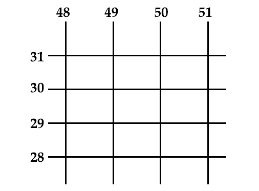
Refer to the image and answer the question that follows: With reference to the scale given in topographical map (2cm=1km), what is the area of the land enclosed between 48 to 50 easting and 28 to 31 northings?
Topic: Area calculation
Previous-year question practice database
Try it
Pick an option and check your answer. The full worked answer is below either way.
Answer
Exam answer
(b) 06 sq. km..
Explanation
Eastings 48–50 span 2 km and northings 28–31 span 3 km; 2 × 3 = 6 sq. km.
In words
06 sq. km..
More from Map Study: Interpretation of Topographical Maps
What is the social significance of the temple that is found at the six-figure grid reference 362001?2026What is the reason for very few settlements in the southeastern quarter of the map extract?2026What is .3r in grid square 3501?2026Identify one relief feature found in the grid square 3796.2026The area shown on the map extract has seasonal streams, but in 39__ a large perennial water source can be seen. What may be the reason for the presence of this large perennial source of water?2026Which other source of water seen on the map extract is perennial?2026